
Potential Nitrogen Removal by Restoring Wetlands on Retired Cranberry Bogs
Modeling Nitrogen Load Reductions from Restoring Wetlands on Retired Cranberry Bogs
I am please to share a new open access publication from our research team at US Department of Agriculture — Agricultural Research Service and Partners at Woodwell Climate Research Center and Buzzards Bay Coalition. The citation and access links and highlights are given below.
Adrian Wiegman, Casey Kennedy, Chris Neill, Rachel Jakuba, Molly Welsh, David Millar, and Anthony Buda.“Modeling attenuation of nitrogen loads delivered to coastal bays from ecological restoration of cultivated wetlands,” Journal of Geophysical Research: Biogeosciences, September 2025. DOI: https://doi.org/10.1029/2025JG008742. (CC-BY-NC)
Coastal water quality in Southeastern Massachusetts is declining due to nitrogen pollution, primarily from human waste (discharged via septic systems), turf fertilizer, and atmospheric deposition. Wetlands act as nitrogen sinks, so historical conversion of wetlands to cranberry farms has reduced the area of functioning wetlands and the capacity of watersheds to attenuate nitrogen.
Restoration of retired cranberry farms offers an opportunity to bring back some of this natural nitrogen attenuation. Until now, we lacked a clear picture of how much nitrogen reduction might be possible, and where restoration could have the greatest impact. Our study addressed these gaps.
Our team adapted a U.S. Geological Survey groundwater models* to:
- Map contributing areas – identify the upstream land draining into each cranberry farm.
- Estimate nitrogen load reductions – quantify potential reductions from retirement and restoration of 984 farms.
- Scale up results – sum reductions at the watershed level for 24 coastal embayments undergoing nitrogen TMDL planning, including those draining to Cape Cod Bay, Buzzards Bay, and Nantucket Sound.
*We used outputs of 3D MODFLOW models to develop 2D models of ground water elevation. These same MODFLOW models were previously used to estimate watershed boundaries and groundwater travel times in TMDL plans developed by the Mass Estuaries Project
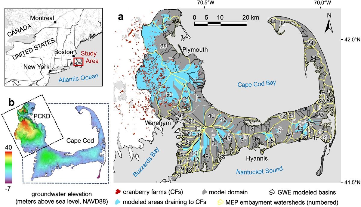
Figure 1 from the article Study area map showing groundwater basins, watersheds, and modeled areas draining to cranberry farms in Southeastern Massachusetts (full caption given in publication). (CC by NC)
- For full restoration of all farms, potential nitrogen load reductions varied by embayment:
- <3% reduction in 9 embayments
- 3–10% reduction in 7 embayments
- 10–30% reduction in 8 embayments
- Potential for nitrogen was driven largely by the contributing area that drains through cranberry farms, which varied substantially at the farm level and at the watershed scale.
- The potential for nitrogen reduction is therefore highly site-specific.
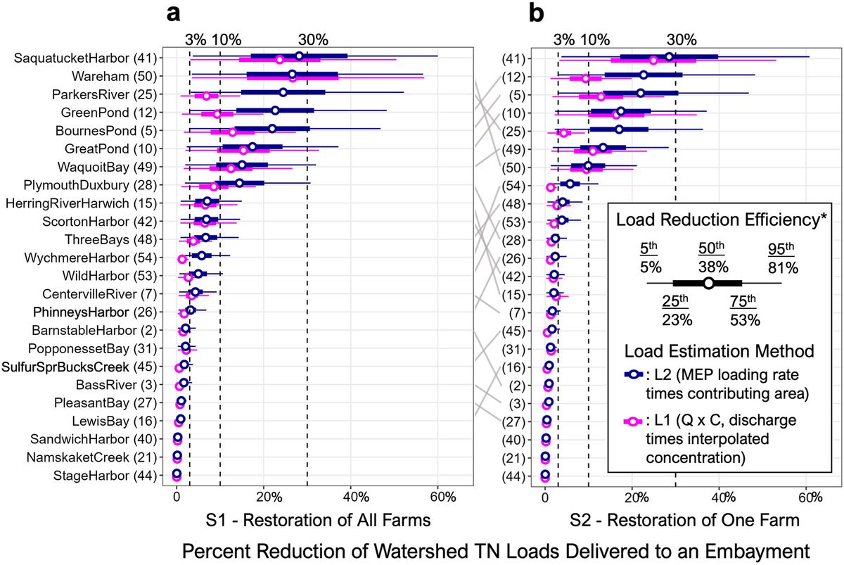
Figure 6 from the article showing (a) Potential reduction in watershed TN load (%) resulting restoration of all farms within an embayment and (b) restoration of the one farm that receives the highest N load. *Load reductions are shown for percentiles of load reduction efficiency (Er) for created and restored temperate surface flow wetlands compiled from two meta-analyses (Land et al., 2016; Walton et al., 2020). Magenta points/lines show load estimation method L2 (MEP), and dark blue points/lines show L1 (Q × C). Note the change in rank between scenarios (gray lines connecting an and b). See method details in Table 1. (CC by NC)
- Restoring functioning wetlands on retired cranberry farms can substantially decrease nitrogen inputs to some coastal bays.
- Attenuation potential depends strongly on farm location and drainage area.
- Targeting restoration in high-potential areas is critical for efficient use of conservation resources.
- We estimate that many of the highest ranking bogs, such as flow-through bogs located along the Marston Mills River, the Coonamessett River and Cold Brook, are in plans for or have already undergone restoration.
The model we present is best viewed as a screening tool — a way to identify promising sites where restoration may deliver the greatest water quality benefits. We hope work with regional stakeholders to integrate our results with ongoing prioritization efforts, such as Making Space.
As the paper notes, field monitoring is still needed to document is needed to document the nitrogen removal benefits of restoration. Stay tuned for updates from Sarah Klionsky, and Chris Neill, who have done this important work on the Coonamessett Lower River and Casey Kennedy and Molly Welsh, who have monitored Tidmarsh Wildlife Sanctuary and several other bogs. It is important that supplemental hydrology and water quality monitoring plans be developed anywhere where water quality and nitrogen loading are of concern.
Water quality, stream flow, and MODFLOW data files are publicly available and cited within the main article (Jakuba et al., 2021; MEP, 2025; WPP, 2024; Woodwell Climate Research Center, 2024; USGS-NWIS, 2024). These data as well as scripts for preprocessing, geospatial modeling, and postprocessing are hosted on the authors GitHub repository https://github.com/arhwiegman/Cran_Q_C and preserved on Zenodo https://doi.org/10.5281/zenodo.15757982 (Wiegman, 2025).
We sincerely thank the late Brian Howes and his team of associates at UMass Dartmouth for their service to the Municipalities of Southeast Massachusetts by collecting data, developing models, and documenting efforts to support watershed nitrogen management as part of the Massachusetts Estuaries Project (MEP). Without data from the MEP this study would not be possible. We would also like to thank John Masterson and Tim McCobb of U.S. Geological Survey for providing MODFLOW model files for PKCD (Masterson) and Cape Cod aquifers (McCobb). Ed Eichner of TMDL Solutions and longtime colleague of Brian Howes provided geospatial data and supporting information on the MEP reports.
September 26, 2025